
Written By ~ John and Fran Greig
Participants ~ TLCC Members
Duration ~ Day Trip
Destination ~ Steep Point, WA
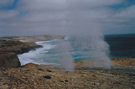
You can also visit the spectacular Thunder Bay Blowholes, where you might see “blows” nearly as good as Kiama. Other blowholes can be seen further down the coast at False Entrance.
To access Steep Point, take the Useless Loop Road which commences 12 kilometres past Hamelin Pool, on the way to Shark Bay, and follow the signs. From Hamelin Pool, (a great camping area and home of the stromatolites), a return trip to Steep Point can easily be completed in one day.
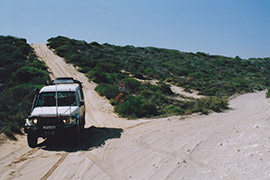
With tyre pressures reduced to 20 psi or less, the final 40 kilometres, which is sandy 4WD, is easy to traverse. There are a few dunes to climb, but nothing difficult. When you come to a “Keep Right” sign you are at “Tin Hill” which is the steepest dune. The good news is that you descend “Tin Hill” on the way in, and take an easy by-pass on the way out.
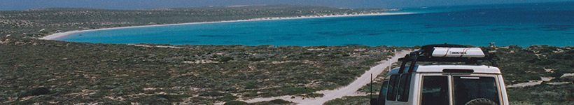
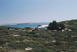
A few kilometres further on, a sign directs all visitors to report to the Ranger Station. And what a great location!! Absolutely stunning views of glorious, crescent shaped beaches curving away into the distance with azure blue water gently rolling onto the brilliant white sand.
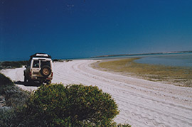
If you don’t have a WA National Parks Pass, you will pay for your visit at the Ranger Station and receive a mud map. There are pit toilets near the two main camping locations, but no other facilities, and no fresh water. The most popular camp site is at Shelter Bay which offers good protection from the prevailing winds. Small boats can be launched from its beach. The camping area at Steep Point itself, in contrast, is quite rocky and exposed. All camp sites MUST be booked in advance. (See below).
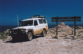
From the ranger’s cottage to Steep Point is about 15 kilometres. You can access the Point and park right beside the sign to record your visit.
There are two ways to exit Steep Point. The easiest way is to simply go back the way you came in. The other way is to take the track along the incredibly spectacular Zuytdorp Cliffs. The track is sandy and traverses areas of sharp little limestone ridges. There are a few places where the side angles get quite exciting, particularly in a Troopy with a spare wheel on the roof rack! But you do get magnificent views along the very rugged, windswept coastline. Kilometres of towering, 100 metre high limestone cliffs drop sheer to the booming, surging surf below.
You might also see fishermen abseiling to their favourite fishing spots or fishing from the cliffs using a variety of innovative techniques. Helium filled balloons take their lines out and “flying gaffs” are used to haul fish up the cliffs. The area is a Mecca for fishermen, particularly during summer, and offers exceptionally good shore based game fishing.
After leaving the Thunder Bay Blowholes, the track heads back inland. At that point, its direction gets a little tricky. You descend a short dune, into a small “fishbowl” and then have to climb another short, but steep little dune, and make an immediate right turn as soon as you hit the crest. After that, it’s an easy trip to rejoin the main track a few kilometres short of the “Tin Hill” by-pass.
If you decide to exit via the Thunder Bay Blowholes, and aren’t accompanied by someone who knows the area, it is strongly suggested that once you hit the little dunal area, you first walk the tricky bit, and mark it, so that you know exactly where to drive.
Once back on the main road, it’s time to put some air back in the tyres, (so don’t forget your compressor), and head for wherever it may be that you are next going to savour the delights offered by the Shark Bay area of Western Australia.
P.S.: Information regarding the gaining entry and camping permits for Steep Point is available from the "Track Permits" section of the TLCC website www.tlcc.com.au. Go to the Home Page and click on "Trips", and from the left hand side menu bar click on "Track Permits", then select the Western Australia pdf and scroll down to "Steep Point".