
Written By ~ Sheila Eiffert
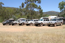
Participants ~ Rod & Karan Perry - 100 Series Piet & Renee De Beer - Prado 120 Douglas & Ruth Gault - 80 Series Robert McLaughlan - 70 Series Robert & Rachael Sharrock - 100 Series Stuart, Michael, & Amy Robertson - 80 Series Richard & Sheila Eiffert - 100 Series Trip Leaders Ken Ribbons & Diana Morgan - 100 Series
Duration ~ One week
Destination ~ Snowy River area
Day 1 – Wednesday
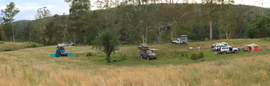
Eight vehicles met at 2:30 pm at Bombala. After quick introductions to each other and the mandatory group photo, we were headed off in convoy to begin our trip.
Ken, as our Trip Leader, led the way and Stuart took up tail end Charlie. We headed south, down to Delegate where we stopped at the local Bombala Platypus Reserve, which is located 4.2 kilometres from the town centre. Even though this is an ideal spot to see platypus, we unfortunately did not see any. However the raised viewing deck was great and the on-site information board provided us with comprehensive details about the platypus.
Back on the road we headed down to Delegate a small town in NSW that lies just a few kilometres from the state border between NSW and VIC. We continued south to Mount Delegate where we hit our first dirt going up on a fairly graded track that offered us our first taste of the spectacular views we were going to see and the fun we were going to have on this trip.
Mount Delegate is situated just across the VIC border and because of its height, at approx. 1325 m, it now has several telecommunication towers providing services to both NSW and VIC. These are built onto a Forestry lookout that is used to watch for fires. The lookout guide was in residence and came down to talk to us, explaining about his job and the tower. On a clear day he can see Bass Strait and we were fortunate as he allowed us a closer look at the tower.
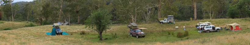
It was a lovely hot afternoon as we left for the Delegate River campsite. A large bushy campsite that they say is beside the Delegate River, although Robert and Rachel went out to find it and gave up. So after setting up camp, we just relaxed and enjoyed happy hour while getting to know each other. Ken had started a campfire, which was nice, and then suddenly it got a bit cold. Within an hour, everyone was huddled around the fire as it just kept getting colder and colder. Layers of clothing started being put on until the cold drove us all to bed.
Day 2 – Thursday
We had a cold start to what was going to be a great day. Everyone was up early and there was a bit of discussion about how cold it had been through the night. Karan was heard to express gratitude that she had brought the doona. We were ready to leave by 8:30 am until it was discovered one couple had stopped to have another cup of coffee. They were promptly fined.
Back on the track we took the Pretty Gully Track to the Delegate River Tunnel. The site is listed in the Victorian Heritage Register and was created during the Victorian gold rush. In 1889 the tunnel was dug so that a bend in the river could be mined for alluvial gold with the tunnel being used to divert the waters of the Delegate River, effectively cutting off a long section of the original river course.
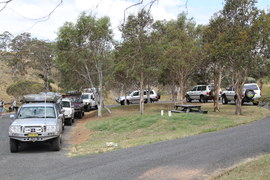
We left and saw our first bit of bush pin striping as we used the Koola Link Track, which I guess hadn’t been used much and was more like a scrubby pathway. This led us onto the Koolablak Track and then onto the Bendoc/Bonang Track. Here we met our only locked gate of the trip and had to turn around. This seemed like a good place to stop for morning tea anyway. Backtracking put us onto the Bonang Highway for a little while before everyone was pulling up to air down their tyres.
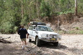
We turned right onto the Tingaringy Track to go down into the valley. It was one of those tracks that starts so steep that you are unable to see the actual track as you turn onto it, and you just have to take a leap of faith. The actual track is quite challenging with two small rivers crossings, and there are steep gravely sections towards the top.
The highlight was of course the Mt Tingaringy summit at 1500 m, where you could see forever in all directions. On Mount Tingaringy we got our first really spectacular high country views.
Here we definitely had lunch with a view before heading down onto the Laurie Track, which gave great adventure to all our 4WDers with some great climbing and descending.
Here we had our only serious incident of the trip with Robert casually calling that he had stopped and was hanging over the side of the mountain, having slid off a rock onto the soft edge. The section was single lane with a very steep drop and very little room to the side. Rachael was out of the car after having crawled over Robert to get out of the driver’s window.
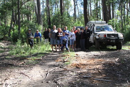
Everyone stopped and recovery options were discussed. We were extremely lucky to have Stuart behind us in the convoy that calmly took charge of the situation and told us what was going to be done. He used his hand winch and a tree on the high side to pull Robert’s car sideways to safety. It only took him about 30 minutes once he had assessed the situation to perform the recovery and it was done to the book. Just like I had seen it done at Driver Training, it has made me consider doing the recovery course! I commented on this to Stuart who quietly smiled then said he had done many years as an instructor at Driver Training and apparently using a handheld winch is like riding a bike - you just don’t forget how.
Next we were onto the Armstrong Track, which had an extremely steep descent and gave us a taste of the some of the tough tracks we were going to experience throughout this trip. We then headed south to the famous McKillops Bridge, which gave us access to the eastern side of the Snowy River where we stayed for the next two nights at McKillops Bridge campsite
Day 3 - Friday
As the previous day had been pretty full on, and we didn’t have to move camp, we had a later start this morning with the convoy out by 10 am to explore the Snowy River area.
First, we had a look at McKillops Bridge, which is one of Victoria’s sites of historical interest as it represents an example of early European settlement and land use. This bridge is one of only two bridge crossings of the Snowy River in Victoria, and significantly marks the area that was worked for silver and lead in the 1890’s.
Then we were off to see Little River Gorge, Little River Falls, and Little River Junction. To get there we had to use Bonang/Gelantipy Road. The ascent up to Little River Gorge from McKillops Bridge was very narrow making dealing with oncoming traffic very precarious.
A 400 metre walking track lead to a cliff-top lookout over the gorge. It is to the west of McKillops Bridge and downstream from the junction of the Little River Falls. It was magnificent. Offering dramatic and unexpected cliff-top views over Victoria’s deepest gorge, and dropping 610 m off the Wulgulmerang plateau.
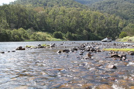
Further along the road we found the Little River Falls car park, with another 400-metre walk to a viewing platform to see the falls. Then we started back to Little River Junction which is where the Snowy and Little River meet, we stopped and had a late lunch here and wished we had all brought our swimmers as the Snowy River was at her best here and it would be a great place to cool off.
We returned to our camp to spend a relaxing evening and enjoyable happy hour together. Just as Robert told all of us to be aware of a really cheeky possum that had come into the camp area, a torch caught Renee and Piet’s rooftop tent, clearly showing the cheeky possum three quarters of the way up their ladder going into their tent.
During the evening we all became aware that a medical problem had occurred for Michael. We tried to help alleviate the pain but during the night it became obvious he needed emergency medical help.
Unfortunately help could not be raised before 6:00 am and would not arrive until 10 am the next day.
Stuart and his family was the first of a few members who had to withdraw from the trip - our first DNF.
We continued on with all our heartfelt concerns being left with Stuart, Michael, and Amy.
Day 4 - Saturday
We were back on the track by 8:30 am. Going back across McKillops Bridge and continued east for about 700 metres where the Deddick Trail is found on the right heading south. It is on the eastern side of the Snowy River a 43 km four-wheel drive track that travels through the heart of the Snowy Mountain National Park. This trail has great views and adventurous 4WDing.
The Deddick Trail is an amazing track through the wilderness zone of the Snowy River National Park in Victoria. The trail itself started as a succession of generally low range ascents over rocky and rutted terrain followed by steep and rough descents to beautiful secluded valleys holding beautiful ferns under tall trees with dappled sunlight filtering through.
Then for approximately 10 km the Deddick Trail climbed continuously from the 200-metre elevation of McKillops Bridge to the top of the range at Mt Joan (1000 metres).
This was the steepest part of the Deddick Trail. To get to the top of the range we used an adrenalin rush ascent called the Staircase that was gravely and very steep and seemed to go on forever. Here it was essential that each vehicle ascended separately, radioing to the next vehicle when it safe to proceed to the top. We stopped and had lunch at the top of the Staircase.
Ken contemplated staying at the Waratah Flat camping area, however the track down to it was very overgrown so we pushed onto Jackson’s Crossing by continuing a further 13 km on the Deddick Trail to the intersection with Yalmy Road that led down to Jacksons Crossing.
Here we crossed the two wide fords of the Snowy River and setup camp on the banks overlooking this beautiful river.
For the trip Di had asked us to all hunt down and gather foods which were locally grown or produced in the area of the planned trip for a shared pre-dinner nibbles plate each night around the campfire. We searched the banks of the Snowy River for an appropriate campsite. Robert won this award by finding a Plum Tree laden with fruit that we all enjoyed.
Day 5 - Sunday
By 9:00 am we were leaving our Snowy River Camp and going into the township of Buchan for a needed refuel and re-stock. Apparently, ice creams were high on the list of many members’ necessary requirements.
We left the Buchan travelling northwest via the Timbarra Road to the Timbarra bush-camping sites, which are tucked away beside the Timbarra River. The Timbarra area is a fairly remote and very scenic area in East Gippsland on the Timbarra River. It offers excellent camping with two main camping areas at either end of a 5 km section of the river with smaller bush campsites spread well apart in between. The only facilities in the area are a toilet at the two main sites.
Apparently, there is good trout fishing in the Timbarra River (although we didn’t get any) and quite a few tracks to check out if you have a 4WD vehicle. Although be warned, signs stated the tracks around the river and campsites can become very slippery in the wet. We set up camp early and then decided to go out for a bit of an explore and hopefully to find some huts.
We started by going out on the Scorpion Track heading towards the Moscow Villa/Bentleys Plain Huts to the Washington Steam Engine
The tracks were a lot of fun until we suddenly all realised that communication was lost with the last couple of vehicles. Concern turned the convoy around to discover that our last vehicle had a break down.
Douglas and Ruth’s car was overheating and something in the engine was smoking. After discussion it was agreed that Ken would lead them out quickly to get help at the towns of Swifts Creek or Omeo whilst Piet and Renee became Trip Leaders and used their breadcrumbs to lead us out of the tracks back to the campsite.
We were all extremely sad to see Douglas and Ruth leave – our second DNF.
Day 6 - Monday
Next morning we were in convoy by 8:30 am. Now we were in the farming land north of Gelantipy which is not a region we hear much about - especially not since the area was devastated by the 2003 alpine fires.
Another reason for the quiet could be the declining number of people living in the main settlements of Gelantipy, Wulgulmerang, Seldom Seen and Suggan Buggan. Some areas have as few as two permanent residents! However, the dwindling populations are not apparently bothering the farmers who remain, many of whom were born in the region.
We travelled along the Timbarra Settlement Rd stopping to check out the Green Hills Forestry Huts on the side of the road and then took the Glenmore Track up to Mount Stewart to have morning tea at its scenic reserve. Then onto the 4WD tracks, Statham & Bald Hills Track, which also serves as a boundary line between Forestry & the Alpine National Park to the Seldom Seen Tower Communications and Fire Lookout Tower.
We stopped for lunch at Seldom Seen, which is located within the State Forest. As Seldom Seen is one of the higher localities in Victoria, being 979 m above sea level, it gave us magnificent views and it was one of the few places any of us got phone reception - everyone with Telstra was in luck and took advantage to ring home.
We then travelled onto Suggan Buggan, which is a tiny mountain town near the NSW-VIC border on the edge of the Snowy Mountains. I found the origin of its name interesting: It seems that the town’s name could of come from the Aboriginal expression ‘bukkan bukkan’ which was a term used to describe bags/baskets made from grass.
And when the pioneer family the O’Rourkes, first came into these mountains, their children travelled in these baskets. Sugan became Suggan and Buggan was probably tacked on as a rhyme, or perhaps a play on the phrase “snug as a bug in a rug’.
The main feature of Suggan Buggan is an old school house, built in 1860. In 1865 Edward O’Rourke constructed the old school house that still stands today.
The smaller of the two rooms was for a tutor named Ballantyne who was hired to teach O’Rourke’s thirteen children. A man named Tom Dillon, who worked for the family, is buried in a grave at the top of the hill near the school house. He was a ticket-of-leave man; a convict who was granted freedom of lodging and occupation within a given district until the termination of his sentence.
Current owner Mr Hodge has recently built a fence around the old school house saying “It’s important to preserve the local history. This is the place where my grandmother and ancestors went to school,” says Mr Hodge. “It’s probably one of the last buildings of its type in Victoria.”
From here we went onto the Willis Campground, which is on the NSW-VIC border and is a lovely place to camp. We setup camp and all went swimming in the Snowy River beside us.
That evening was New Year’s Eve so we all partied beside the fire and stayed up rather late
Day 7 - Tuesday
As this was the day that the trip “formally ends” everyone woke up late and took their time settling into the morning. Most of us were luckily staying for the second trip that Ken and Di had also organised, however Robert had to leave as work was calling.
As each of us was ready we left the Willis Camping Area via the Barry Way to return home or go to Jindabyne to restock and get a real hot shower.
From all of us, a big thank you goes to our wonderful leader Ken and his lovely co-pilot Di, for putting this trip on and for all the work put into it to ensure it was so well planned. It was all of your effort that made the trip such a thoroughly enjoyable, and memorable experience.